Veggie Voyagers

Couple travelled 30 states and 3 Canadian provinces between 7/07 and 5/08 running their 1987 Ford truck on straight veggie oil. The blog continues with a focus on the natural world and energy politics from a personal perspective

Thursday, October 31, 2013

Halloween dreamin'

 We got into Escalante town yesterday afternoon and had espresso plus I was excited by the beauty of where we camped, about 10 miles from town, on Spencer Flat Road. Plus, my brother is coming out today and so I didn't sleep well.
 I dreamed a frightening dream but circled round before morning to bring the dream into conscious resolution. What had terrified me early in the dream was a force of nature with no evil intent. Just how nature is- raw and true to the elemental.
 In the morning we went for a loop on the sliprock, trying to avoid the living soils and wondering at the changes of light and mood from the angle of the sun. Awake. Alive. Grateful.


Wednesday, October 30, 2013

Kanab to Bryce

 We wanted to take the "short cut" through the Grand Staircase, up Skutumpah Road but the Impassable when Wet sign did sort of put us off. So, we still ended up slogging through on the Glendale Bench Road to the little town of Glendale where we were able to buy sweet apples and then head north into a snow storm...
 We stayed in the little community of Hatch for the night and it was icy cold but snug in our Veggie Voyager. In the morning we headed East to Bryce Canyon. I wanted to see it with snow on it and got a lot of wonderful photos... here's one and then a closer-up of the same area. Exhilaration and Inspiration in the sweet, sharp morning air.

 After our eyefulls there we headed further east... going past this dinosaur rich Kaiparowits Formation and into the town of Escalante.
 Maybe I'll get some more photos to post tomorrow but this little snow goblin on the canyon rim this morning reminded me that magic keeps happening and that Halloween is the richest time of the year for expanded sensing into all the texture of the worlds. Enjoy!

Tuesday, October 29, 2013

North Rim to White Pocket

 We took a "short cut" between Hwy 89a and 89 on House Rock Road. At the southern end we found some young ornithologists from the Peregrine Fund looking out to the Vermillion Cliffs and we got to look through their spotting scopes for good views of the California Condors on the distant cliffs. It was so wonderful to see these introduced great vultures soaring around the cliffs! The hunting areas of the Kaibab mesa were covered with signage encouraging hunters to bring their "gut piles" in if they used lead shot... hopefully there will be enough safe natural food for these great birds to survive in Arizona.
We'd heard from my brother and a friend about how we HAD to go to a place called "the wave" which isn't on any of our maps. We just floundered into the Vermillion Cliffs National Monument on the tail winds of another tourist but we were really unprepared for the sandy roads. (They look like waves don't they?)
Michael stopped to process (30 gallons of) veggie oil after the people we were following got stuck and then turned back. Another couple came along as we were deciding to go back and their enthusiasm for the area, encouraged Michael to let more air out of the tires and go on. So, after scratching the roof of the VV and busting one of the camper tie downs we made it to White Pocket which shows the characteristics that the North Coyote Buttes (equal to "the wave.") is famous for... swirling sandstone colors.
A storm was coming on so we didn't stay too long since we couldn't anticipate how well we were going to do getting out but we did make it out and completed the rest of the House Rock Road before heavy rain set in during the night, snow at about 5500 feet. The beauty of Utah, since we are once again across the border, continues to amaze us. (Click on this photo!)

Page to North Rim

 This is the Colorado River below the Glen Canyon Dam at Navajo Bridge. Notice the strange combination of green and sediment in the water... From here we went down to Lee's Ferry where  those who float the Grand Canyon put in. (Closest I'll ever get to the experience... ) After that we took out from Marble Canyon across a vast plateau and uphill to the Kaibab forest... Ponderosa pine and high country critters... and lots of hunters. Guess this guy was smart to stay inside the protection of Grand Canyon National Park.
 The most interesting thing I saw was this Halloween looking little Kaibab squirrel with his big ear tufts and glorious tail.
 The views from Bright Angel Point were disappointingly hazy with pollution hitting up on the chilly morning air looking into the sun plus there were controlled burns adding their soot to the mix.
 Still, over by the campground, away from the tourists with just a few hikers still tenting there, I was able to find the peace and beauty of this most Grand Canyon.

Thursday, October 24, 2013

Coal Fire vs ?

 We are about 95 lake miles and over 450 land vehicle miles from Hall's Crossing of Lake Powell. This is a photo of the marina taken from the campground area. I wondered at the time why the sky was so hazy when we were so far from any large cities or freeways. It's been a week since we left there.
 Yesterday we were back at Sand Island after two days around Blanding. (Michael processed 40 gallons of veggie oil there so that helped with all the miles since.) The brilliant show put on by waves of cottonwood trees on both sides of the San Juan completely warmed my heart and the walk east along the low canyon and seeing hundreds more petroglyphs also left me with great warmth for this remarkable place.
 The next day after some nice human interactions we went off across the Navajo Nation and Monument Valley. The Nation is rural and mostly seems impoverished. Just like with the ancients, thoughts and impressions and opinions leaped up over the miles to be released into the clear knowing that I can't and don't know anything.
 But when this coal fire plant loomed up all that went out the window. I have opinions and will voice them. This plant isn't owned by the Navajo Nation but they do lease the land and the coal comes from the Peabody Coal plant near Kayenta. It employs many Navajo people in a landscape devoid of other opportunity to earn a living. It increases asthma rates and is blamed for mercury accumulations in the fish in Lake Powell. It is Mordor, the 8th largest single source of climate change carbon in the country! It must not be just EPA updated or switched to natural gas... it needs to become renewable-- solar and wind. I can clearly see the entire Navajo Nation on solar. There is no reason not to start now rather than scare the entire community. (Signs read: Stop Obama's war on coal fired plants!)
We're in Page and when in Rome you go to the Glen Canyon Dam and read about the Colorado and the whole wonder of all the modern crazy making. It is so much bigger than I can address. The water hunger of the South-west... the inevitability of all that has come to pass and the great exploration and engineering feats that will never be undone. Here at the Page Library I'm reading the Old Spanish Trail Association newsletter (Spanish Traces) and recognize the trail even from the late 1700s leading to today. I'm watching the sun set in glorious ephemeral clouds out over ancient seemingly impenetrable mesas and rock formations. Nothing lasts and my brain is easily over-whelmed. I'm surrounded by Indian teenagers staring down at their phones like teens everywhere. What future are we passing into? Back to my picture window for now... back to the sunset. 

Sunday, October 20, 2013

Utah treasures

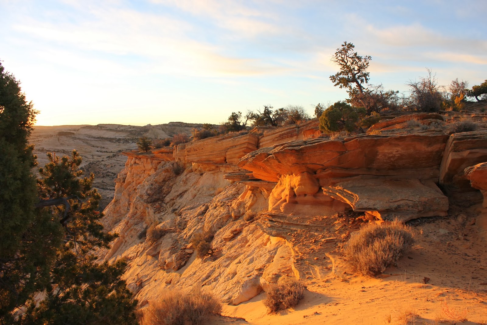
When we left Kathy and Dale in Mexican Hat we went first to Gooseneck State Park but it was mid-day and glaring bright with just the wonder of the San Juan River in her fixed meanders below us. We could only imagine how long it would take to paddle them... We then went back up the Moki Dugway and on to Natural Bridges National Memorial (federal stalemate finally broken!) We climbed down to the Sipapu Arch and Michael hiked to the next arch, Kachina (photo below,) as I labored my way back up from the riparian plain at the base of the canyon by Sipapu.

 Next we went on to Hall's Crossing at Lake Powell. The first day we put in with our little 2 HP motor on the Soar inflatable canoe it pooped out when we were a few miles out and we had to paddle back at dusk. The second day we managed to putt our way up the remnant of the Colorado and all the way up Moqui side canyon. The water level is down at least 40 feet but it is unimaginable how much water is in that lake... I could feel the drowned life of the valley floor below us and the spirits of all that life gone... it is just such a remarkable anomaly.. to be out on all that water in the middle of the natural desert. Our journey was long and we returned well after dark... found our Veggie Voyager to be out of propane so had dinner on our Jetboil camp stove.
 Today was a blessing... we visited the Butler Wash ruins of the Ancestral Puebloan people who left their home about 700 years ago AND we were joined by Kathy and Dale for one last visit to catch up on our post San Juan adventures before going our separate ways again... so surprising and fun to return from our hike to be surprised by

these two bird watchers!

Wednesday, October 16, 2013

Our paddle on the San Juan

 Kathy's feet demonstrate a constant of the San Juan. It carries huge amounts of silt and looks just like chocolate milk. The beaches are mud and the fine silt sand gets everywhere. Pretty on her fine thin feet though, isn't it?
 You can also find comfort under some of the beautiful old Fremont cotton trees...
 Most people carry all their water which makes for a heavy boat. Dale came up with a double filter system that worked well though.
 We had some nice hikes! Sometimes we were with Dale and Kathy and sometimes just us threading our way along. I was moving slowly with a pained back but it never kept me far from appreciation of where we were and the beauty of place and my companions.

9 days on the San Juan River!

 We took out in a cold rain squall last night right at dusk here at the Mexican Hat BLM. That last six miles were challenging with a head wind and that driving rain. I'm grateful to be packed up and back with the Veggie Voyager but I also loved the entire river time experience. Time stretching back to the eroding rocks and messengers of the past.

 Above is a place called River House. We camped and hiked here two days and two days also at a place called "Fossil" due to the ancient Pennyslvania layer, the gray mud like what we saw where the dinosaur's were fossilized but these are "just" plants and shells (wonderful to find 100s in a square foot of rock.)
 There were signs of Mormon and miner efforts to road build and some old trading post remnants but the best was just messages of animal passage through the river mud... a simple reminder of those we share this ancient land with. I'm so grateful for this river time.

Friday, October 4, 2013

Utah!

 We have had such an amazing drive! This is an area with a historical marker... Michael says these are just for white history. Indeed. We have been listening to an audio book about the pilgrims and how they massacred Pequot women and children in the 1600s and sold the survivors into slavery in the Indies--wonder where that historical marker is... This "massacre" was of two white men by Paiute and Ute and the area is referred to as Paiute Pass.
 We camped at a BLM rest stop and a furloughed rest stop cleaner showed us where "Moki Mother" was located in a large amphitheater of red clay down the road from us. We could feel the power of this place... the Hog Creek and sounds of the wind in the sycamore and even passing traffic noises seemed to be coming from the rocks themselves. This pictograph seems to dominate the entire area. She has a white "crown" of energy and strands of white that appear to give her authority in a yoke at her chest. I felt completely sure this is where I want whatever is left of my body after death to be buried in the silty soils below her. This is a place for eternity...
 We came to Glen Canyon the hard way, in the middle of this government shut down. Everywhere was blocked off but we did get good views of the Colorado River emerging below Cataract Canyon.
 Then we went to explore our take out (from our upcoming 10 day paddle down the San Juan River) at Clay Hills Crossing. It was a rough 12 miles in on a bad road and we had a hell of a dust storm last night but it was worth it to get a sense of the place. Michael processed the veggie oil again so we are pretty much back with that discipline.
Lastly, We came down the Moki Dugway that looks down over the Valley of the Gods-- a vast plain with incredible rock outcroppings, like Monument Valley, which we haven't seen yet. We are now in Mexican Hat.. our future stop on day 3 of the river... the only human habitation and alternative take- out...
It is a wonderful place on the edge of the Navajo Reservation. I had fry bread for dinner. I'm so grateful for all this vast beauty... around us, within us.

Tuesday, October 1, 2013

Uinta Basin to the San Rafael Reef

 We traveled a small two lane round to the Nine Mile Canyon that passed through the Uinta Basin where oil derricks pumped every quarter mile in every direction. Hoses of different diameters snaked along the land in every direction. Tanks of water supported each derrick as they marched out to the horizon of this dry land.
 The Nine Mile Canyon was beautiful... petroglyphs of animals along the whole length of the rich valley. After we emerged from the Book Cliffs we stopped on some BLM land and Michael processed veggie oil.
 That night we made it down to the outskirts of Globlin State Park and I got up at dawn to catch the first light and a lone antelope on the slope by me.
 Then we did a "stumble about" through the Goblins. I was pleased that Richard Nixon found a commemorative casting among the hoodoo. Later we left the park and went up to Temple Mountain where uranium was once mined. Then back out to the open paved road, heading south...